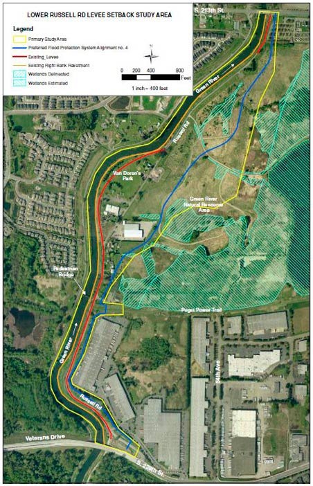
A levee project is expected to cause major changes to the city of Kent’s Van Doren’s Landing Park, the Green River Trail, Russell Road and the Green River Natural Resources Area.
City staff has proposed a concept design in an effort to preserve recreational opportunities for residents despite plans by the King County Flood Control District to set back the Lower Russell Road levee so it can be accredited by the Federal Emergency Management Agency (FEMA). If FEMA certifies the levee, properties are removed from the Kent Valley floodplains and property owners are no longer required to buy flood insurance.
The levee stretches along the east side of the river from about South 212th Street to South 228th Street, a distance of approximately 1.4 miles. The flood district expects to make a decision this year on the preferred alternative for the project with work to start in May 2017.
The flood district will cover the costs of the $17 million project through its annual property tax of 10 cents per $1,000 assessed valuation on county property owners.
“We (city staff) put together a concept that blends the priorities of the project levee setback but still increasing habitat and keeping in mind the existing recreational opportunities that have been part of the community for decades,” City Parks Director Jeff Watling said to the City Council’s Parks, Recreation and Community Services Committee during a June 25 report.
City officials are concerned about the project because of proposals for a setback levee further than required in order to create new habitat that reaches into the Green River Natural Resources Area. The city owns much of the property along the levee.
The location of the 10-acre Van Doren’s Park, 21901 Russell Road, is expected to be shifted as a portion of it sits right along the river’s edge and where plans call for the setback levee.
“There are many project elements which need to be balanced to have a project that is widely supportable,” said Mike Mactutis, city environmental engineering manager, in an email. “Some of the elements being scoped are the proposed road and levee configuration, and layout and potential features of the salmon habitat areas and relocated Van Doren’s Park.”
City and county staff meet about every other week to discuss the Lower Russell Road levee project.
“The county will formally identify a preferred alternative, but our concept looks like it will become a preferred alternative,” Watling said. “Then a more extensive design will be done. The city will have a key role because of the public spaces and we are the primary property owner with the Russell Road right-of-way, the park and the Green River Natural Resources Area.”
More than 40 people attended a county-hosted a public meeting in June about the levee project and the city’s proposal received a positive response, Watling said. He added the community remains engaged to help preserve public access along the levee with the park and trail to keep the city’s recreational opportunities in that area of the river even with an improved and larger levee.
County officials in the spring announced they would delay any work to repair the Lower Russell Road levee by a year to 2017 because a preferred project plan has yet to be chosen.
The county said in its Lower Russell Road levee fact sheet that the existing system doesn’t meet engineering design standards, is difficult and costly to maintain, has over-steepened banks, deteriorating rock protection and slumping riverbank slopes. With a new levee set back from the river, the project will provide greater flood storage as well as improve habitat for fish and wildlife.
Talk to us
Please share your story tips by emailing editor@kentreporter.com.
To share your opinion for publication, submit a letter through our website https://www.kentreporter.com/submit-letter/. Include your name, address and daytime phone number. (We’ll only publish your name and hometown.) Please keep letters to 300 words or less.

