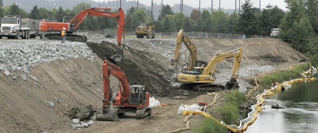
Two Green River levee projects planned by the city Public Works Department will go before the city hearing examiner at public hearings Wednesday, April 4.
“The city has done comprehensive geotechnical and hydraulic studies of the river levees and has identified sections of each levee that do not meet federal standards,” said Mike Mactutis, city environmental engineering manager, in an email. “The sections that need improvements are not at imminent risk of failure, but do need the improvements done before they become a problem.”
City staff must go through the hearing examiner for a Shoreline Conditional Use Permit to construct the earthen berm levees. A 10 a.m. hearing will address the State Route 516 to South 231st Way Levee. A 1 p.m. hearing will address the Boeing Levee Project.
Both hearings are in Chambers West at City Hall, 220 Fourth Ave. S. For more information, call Planning Services at 253-856-5454.
According to city documents, the existing levee along State Route 516 will remain. The top of the new, secondary levee will be 20 feet wide and be between 1.5 and 3.5 feet higher than the existing levee.
The intersection of James Street and Russell Road will be shifted approximately 18 feet to the east to accommodate the new levee berm. Near State Route 516, the existing roadway of 62nd Avenue South will be raised to act as the new levee berm.
The SR 516 to S. 231st Levee stretches about 2.75 miles. Crews will do the work in phases over a few years. The construction work planned this year is estimated to cost $800,000 and includes rebuilding the intersection of James Street and Russell Road further from the river, Mactutis said.
The projects are part of a larger effort by the city to have the entire levee system within city limits accredited by the Federal Emergency Management Agency in order to remove properties behind the levee from FEMA flood maps to reduce development restrictions and flood insurance requirements in the Kent Valley.
Crews will remove and relocate existing utilities and remove trees and vegetation. Disturbed areas will be hydro-seeded and off-site tree mitigation will occur upstream on the river at South 261st Street and 80th Avenue South.
Construction of the first phase, relocation of the Russell Road/James Street intersection is expected to start this summer. Subsequent phases are scheduled to be completed by December 2015 with a total estimated cost of about $20 million.
The intersection work is funded by the city’s stormwater utility fund and is scheduled to be completed this year.
“We are working on acquiring funding for the additional levee construction pieces through the state as well as the King County Flood Control District,” Mactutis said. “Those additional phases can be completed as soon as they are funded.”
The Boeing Levee covers the east side of the river between South 200th Street and South 212th Street. Crews plan to construct an earthen berm and flood-wall levee for flood protection at the city’s Three Friends Fishing Hole Park, adjacent to the river. The berm and flood wall will act as a secondary levee for the existing levee.
That $2 million project is funded through a grant from the state to the Flood Control District, Mactutis said.
“The city’s estimate is that this grant will pay for all the work needed to bring the levee up to FEMA standards,” Mactutis said.
Other levee projects underway or planned by the city include:
• Horseshoe Bend Levee, which reaches from the east valley wall to Highway 167, is funded through a $10 million grant from the state as well as city stormwater utility funding and Flood Control District funding. Additional work along South 259th Street at the east end of the levee as well as west of the BNSF Railroad, is scheduled to be constructed this year. This levee has been highest on the city’s priority list as it protects the east side of the valley north into Renton.
• Hawley Road Levee, which is adjacent to LA Fitness and Holmes Electric, is funded through a grant from the state through the Flood Control District for $900,000 and is scheduled to be completed this year. It includes raising Hawley Road next to those businesses and will protect the area extending north from that levee.
• Lower/Lowest Russell Road Levee, which extends from the South 231st bridge north to the South 212th St. Bridge, is in planning and design through funds from the city stormwater utility.
• Briscoe/Desimone Levees, which extend from the South 200th Street Bridge north to South 180th Street, is also in planning and design through funds from the stormwater utility fund.
For all of the levee projects, the city also has Conditional Letter of Map Revisions (CLOMRs) submitted to FEMA and is working with FEMA on resolving questions with those applications.
Talk to us
Please share your story tips by emailing editor@kentreporter.com.
To share your opinion for publication, submit a letter through our website https://www.kentreporter.com/submit-letter/. Include your name, address and daytime phone number. (We’ll only publish your name and hometown.) Please keep letters to 300 words or less.

